Measurement Devices
There are many types of Laser Measurement Tools available that have a complicated variance in accuracy depending on the devices capabilities / methods used for performing measurements / calculations used to produce final measurement totals. These devices can cost as little as $100 and as much as $50,000. Ours is closer to the $5,000 range where most hand-held devices fall below $300.
Most prudent Appraisers in today’s market use the hand-held laser devices since they provide fast “gun-sighted” measurements that are far more accurate than using a standard tape measure. Only top professionals invest in tripod-mounted systems that offer the most precise measurements.
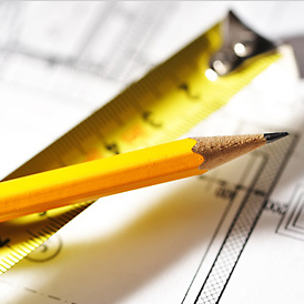
The Tape Measure should only be trusted by craftsmen and contractors for the construction of their projects.
They can be used when approximate or estimate measurements of basic spaces or rooms are needed. In most cases, the measurement is “gun-sighted” and rounded to the nearest sensible measurement (6in or Ft). Tape-Measuring an irregular room can be a headache and calculating the actual Sq.Ft. of several irregular rooms is daunting.
Many Realtors use these along with basic techniques to measure the length & width of a room and often rely on questionable Tax Records for the SqFt Calculations. Tape measures for Sq.Ft. Calculations should be avoided, even by professional services as the liability of this method can result in a lawsuit over discrepancies.
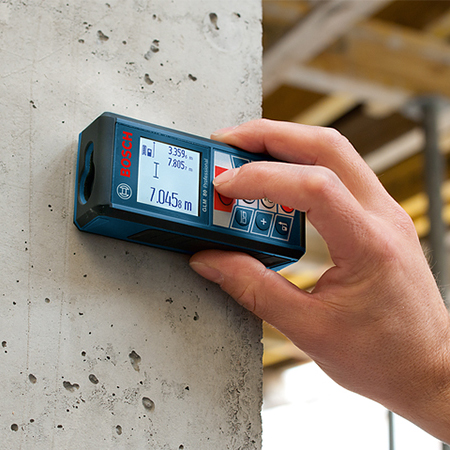
Hand-Held Laser Devices are somewhat inexpensive ($100 up to $500) and can be are extremely accurate on their own but are only as accurate as the method used to curate the measurements. Their accuracy is limited to “Hand-Held Accuracy”; a slight angle can dramatically change a simple measurement without being noticed.
Modern Licensed Appraisers use these because they are affordable & fast, and typically perform their Sq.Ft. Calculations using a special Mobile Device Application; still, the reliability of the information is only as reliable as the detail spent on the process of curating the measurements. In most cases, the irregularity of a space is not taken into consideration.
Avista Media does not use Hand-Held Measurement Devices.

Tripod-Mounted Devices are much more expensive (from $2,000 up to $50,000+) and extremely reliable and precise, mainly because the measurement tool is mounted on a tripod and leveled & plumbed before measurements are taken to eliminate “long measurements”, reducing “Measurement Uncertainty”.
Licensed Land Surveyors and Industry Architects rely on these types of systems as they accurately curate multiple complex measurements from various locations within that space. A computer is used to align the measurement locations to build a laser-accurate 2D Floor Plan or Plot of the space. Some devices perform lateral scans of a space to measure across an sector of space or a 360° collection of measurement data capable of creating a 3D Model of the space.
Avista Media uses this type of system.
The Measurement & Mapping Process
Producing Laser-Accurate Floor Plans & Precise Area Calculations requires an overwhelming amount of Complicated and Complex Measurements. The process is commonly known as “Surveying” a Space or “Mapping.”
Hand-Held Mapping
Typically, these measurements are done across a room from one wall or corner to the opposite wall or other measurement location (i.e. where a Carpeted Living Room room meets a Tiled Kitchen; the distance from a wall to the edge of a window or doorway; the size of the window or doorway; the distance from a wall to an irregular wall); to accurately calculate an exact SqFt of a space, the process must be done for each separate wall angle.
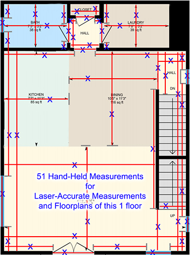
Measurement Points must also square, level & perpendicular to the wall being measured in order to be accurate. Slight angles over a distance will result in “Long-Measurements.” The more irregular a room is, the more complicated this process gets. In this example (Fig.01), this single floor of a 3 floor building would need 51 Hand-Held Measurements to locate all irregularities and produce a laser-accurate floor plan and area calculations. The opportunity for errors is multiplied with every measurement. This process can take an entire day for a trained professional to map a space, and several days to a week to produce accurate floor plans and area calculations.
Avista Media Real Estate Services does not use Hand-Held Measurement Devices; we use a Tripod-Mounted Device engineered from Land Surveying Technology that is used by industry-level architectural & construction professionals.
360° Laser Mapping
Mapping a room with a 360° scanner maps & measures a space from a location within a space where the laser system laterally scans the entire wall area that is visible to the laser. Multiple scans are performed from nearby or conjoining locations to create “Overlapping Spacial Measurement Data” which is similar to what Professional Land Surveyors call “Backsighting“, which is a critical part of verifying measurement accuracy as a device transits from one point to another. Backsighting with overlapping 360° measurement data using a tripod-mounted scanner eliminates any opportunity for measurement errors. Handheld devices do not have this capability.
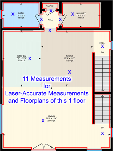
In this example (Fig.02), this single floor of a 3 floor building only needed 11 Mapping Locations to accurately locate & measure all irregularities. A single 360° scanner system can map the most complicated spaces in under an hour. The data is assembled on a PC and a team of drafting professional easily defines room dimensions and places the room features (i.e. Living Room & Kitchen; locations and sizes of windows & doorways; irregular wall locations). The end result is laser-accurate floor plans and area calculations in about 24 hours.
Our Measurement & Mapping Process:
- Simply put, our device is placed in a location within the space (as shown in Fig.02 above) that has laser-visibility to multiple points of a space where a Rotary Laser laterally scans the entire room to produce 360° spacial measurement data from that tripod location.
- We then relocate the to a conjoining nearby location that has clear visibility to the previously mapped space and perform another scan.
- When a space is complicated, not perfectly square or rectangular, or Advanced Measurements are needed, we perform additional mapping scans within the same space from different locations to make certain that the space is measured & mapped as accurately as possible. While it adds a bit of time for the additional scans, this process creates the kind of accuracy one would expect from a Licensed Architect or Land Surveyor.
- All relevant spaces are scanned even if they are small or not shown in our Virtual Tours, like closets, hallways, cold spaces, door thresholds, garages, and more. Additional mapping scans are performed for larger spaced that warrant multiple points of views in the 3D Virtual Tour of that space.
NOTES: Timeline: A Standard 3D Virtual Tour with Floor Plans & Measurements takes about 10 to 25 minutes per 1kSqFt depending on how complicated a space is or what may be in the way of the process; Advanced Measurements takes about 20 to 45 minutes per 1kSqFt; Minimal Tours take less than 10 minutes per 1kSqFt and are less accurate because only specific spaces are mapped. Photography is an add-on service that has a separate timeline. ATTICS: We typically do not scan unfinished attic spaces as they are often never relevant to the Square Footage Calculation of a home for sale, but we can scan an attic upon request if it has a standard “Walk-Thru” door or is relevant to the project needs; if the Attic Space has a Doorway to access, we do “Locate” that doorway so it appears in the Floor Plans. We do not scan attics that are not accessible by a standard walk-through doorway (i.e. We do not scan attics that have Pull-Down Ladder Access). Basements and Garages are typically scanned if they are to be included in the Floor Plans; they are often complicated spaces with nooks & crannies and structural supports; these spaces are typically Below Grade and not included in most listings as “Living Space” or Above Grade Square Footage Calculations (most homes in the US Aare valued on their Above Grade SqFt.). We do not measure “crawl-spaces”.
Understanding Floor Area Calculations

Calculations with Confidence
Our Camera’s laser scanner has a typical dimensional uncertainty of 0.5% or smaller, allow you to confidently rely on your measurement calculations. The laser system itself is accurate to 10mm (0.039in) from a single-scan at its furthest distance. We further reduce the level of uncertainty by taking overlapping measurements. With critical measurement projects or projects for Architects, we perform Advanced Measurements where the scanning process includes a complex number of scans to increase the accuracy of our measurement data and to meet the most demanding needs.
The drafting team follows the ANSI Standards for Calculating Square Footage (ANSI Z765-2003). The document can be found online, we can not legally publish the document. Below, you will see the Method of Measurement that explains the standards used when calculating Interior & Exterior Floor Areas.
Method of Measurement
1. Definitions
Interior Area is a per floor calculation, made by measuring to the inside surface of the exterior walls.
Excluded Area is a sum of interior areas of all rooms (measured to the inside surface of room walls) that are excluded from the Interior Area for a floor. Prescribed area exclusions can vary from region to region. Examples of exclusions are spaces open to below, garages, cold cellars, crawl and reduced height spaces, non-enclosed open spaces, such as decks and balconies.
The footprint of all interior walls and staircases is typically included in the reported Interior Area for a floor.
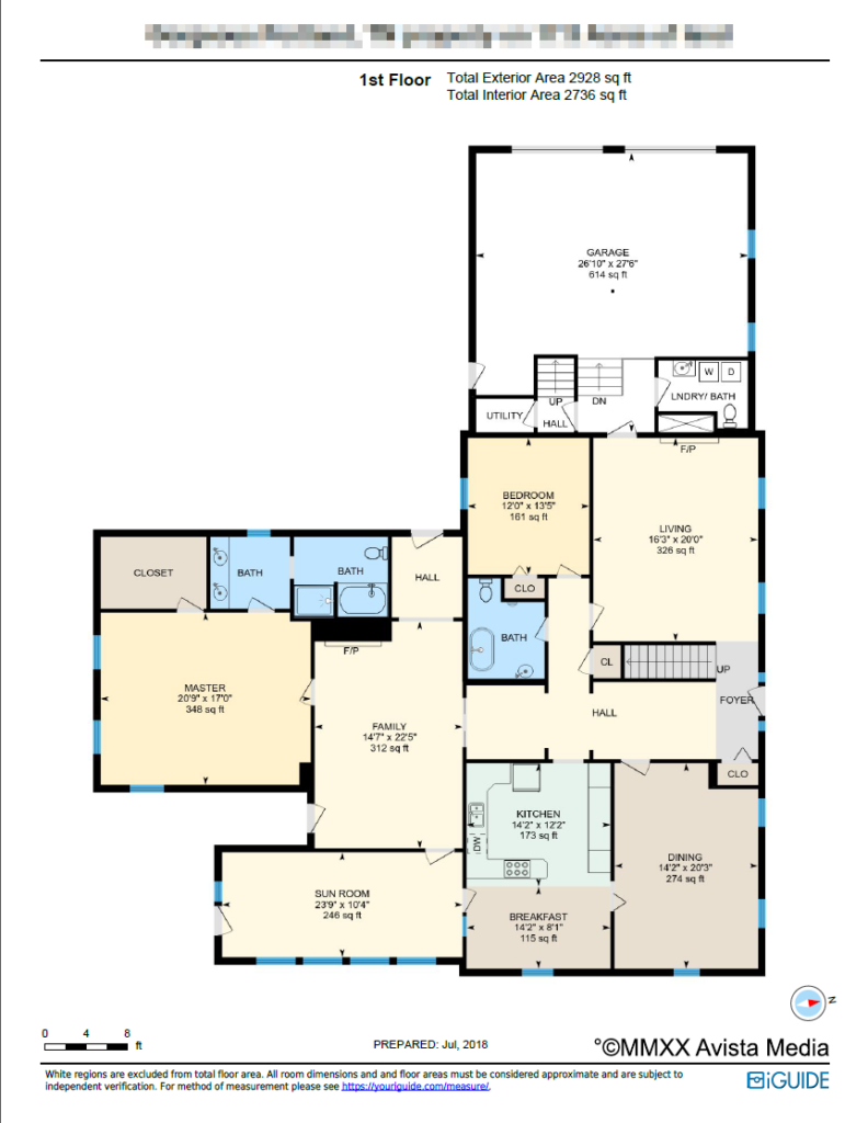
Our PDF floor plans use color to highlight all included areas; Excluded areas are shown white. (see Fig.03 below)
Exterior Area is a per floor calculation, made by measuring to the outside surface of the exterior walls, see below for calculation details.
Grade is the ground level at the perimeter of the exterior finished surface of a house. A floor is considered to be above grade if its floor level is everywhere above grade.
Total Interior Area is the sum of all Interior Areas.
Total Excluded Area is the sum of all Excluded Areas.
Total Exterior Area is the sum of all Exterior Areas.
Unfinished Area is the sum of interior areas of all unfinished rooms (measured to the inside surface of room walls).
Finished Area is Exterior Area minus Unfinished Area. Finished Area includes the footprint of interior and exterior walls.
2. Exterior Area Calculation
Exterior Area = [Perimeter Wall Thickness] x [Perimeter Wall Length] + [Interior Area]
Notes:
- Perimeter Wall Thickness is an independent measurement taken from the property, typically, at the main entrance. Considerations are not made for varying wall thickness around the perimeter.
- Perimeter Wall Length is the sum of lengths of all exterior wall segments on a particular floor. When used to calculate Total Exterior Area Above Grade based on Total Interior Area Above Grade, it is the sum of perimeter wall lengths of all floors above grade.
3. Disclaimer
Avista Media is not a State Licensed Appraisal Service. While our floor plans and measurements are confidently accurate and can be considered “Professional Service Rated” because of the technology used to curate the measurements, all dimensions and floor areas must be considered approximate and are subject to independent verification. Ultimately, it is the project manager’s (or Realtor’s) responsibility to hire a licensed appraiser to confirm measurements – they are typically off by a reasonable number because of substantial difference in methods and technology used to perform the measurements and calculations. Typically having a state licensed appraisal is part of the Real Estate sales process and is always recommended.
As always, we welcome your questions and feedback!